Main

Geographic Information Systems Archives

October 22, 1987

Portrait of the Blogger as a Young Blowhard

I moved to Seattle in January 1986, my first civic involvement was volunteering to help start the Broadway (Seattle) BIA, second was a group called KC 2000. (The end result would be the Metro/King County Merger per the Judge Zilly decision.) These folks would be perceived as the typical regional heavy hitter crowd. FWIW though the earlier, more modest endeavor, sits sweeter in my memory.

This was the end of the Reagan, fall of 1987 when George I was making his run. At that time the economy was tanking, and I used that as a theme for a promotional editorial I wrote in the UW Student Newspaper - The Daily.

Best thing about this event was the UW Students and Faculty I met - faculty included the Geographer/Demographer Richard Morrill and Transportation Engineer Scott Rutherford.

Two student footnotes: The Op-Ed was published by Sally Clark, currently a Seattle Councilmember, and perhaps the best home grown public career resume of my generation, locally.

Asterisk
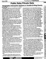
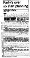
Second was Tom Nolan. At the time he was doing his Master's Thesis on a proposed Computerized Mapping system for King County. Tom currently runs the City of Seattle Department, funded by City Light. This is his Master's thesis abstract/outline relevant to the local history of this profession, a topic I should continue to write on.

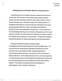
The handwriting should be his.

January 29, 1989

Innovation and Neighborhoods - Tree Planting

As I recall neighborhood matching funds were started in Seattle. I believe they were either Ford Foundation supported or the Foundation noted their success in the first year.

This was just as I was finishing off my degree and I got involved. As a side project I did a proposal for a tree planting in Squire Park, between Seattle University and 23rd. I believe this was the first of its sort. I was not involved in the implementation - as I recall the project was completed by the YMCA led by Richard Conlin, now a Seattle City Councilmember.

One of the things this project did was give me my first opportunity at trying out Geographic Information Services. The graphics here are rough, but they are functional.

March 6, 1994

Access to Public GIS Records

In 1994, under City Attorney Mark Sidran, access to GIS records was actively being debated. That's hard to believe in this day and age - thank current State Attorney General Rob McKenna and the newspapers of this State led by Michael Fancher of the Seattle Times.

At the date of this writing I was employed full time with King County and was attending graduate school in geography, as well as serving on the board of Vision Seattle. I interviewed Tom Nolan(Asterisk), head of Seattle's GIS unit for this piece, but I didn't include any quotes in this article. I don't remember the reasons why.

Besides a question of public record access I'm also 'envisioning' a future for the profession here, to some extent that does seem to be finally happening on a broad scale.

September 6, 1994

Sound Transit Civic

Here's a pretty good looking example of my civic involvement in Sound Transit. This particular example wasn't implemented, but others were. I still think the idea was a good one- reducing tunneling costs by exiting Capitol Hill at Lakeview.

December 1, 2008

Charting the Unknown - How Computer Mapping at Harvard Became GIS

Charting the Unknown

How Computer Mapping at Harvard Became GIS

By Nick Chrisman

2006

This review is a bit like a post-modern piece of art, dangerously self-referential, but, hopefully, also 'true'.

I chose to work in the field of GIS, Geographic Information Services, shortly after completing a Senior Thesis on the subject of Higher Education and Economic Development. I chose the field upon becoming aware of some of the, uh, public-private 'business' practices around the economic development career track - I think a good choice, especially as I'd already had some exposure to the GIS field through government land use internships.

I wasn't actually aware that the software package I worked the most with, ESRI's ArcGIS, was a product of the same factors, and place, I studied as an Undergraduate. A such I found this book particularly interesting. This, also, is the first bit of dangerous self-reference.

The author, Nick Chrisman, was one of two GIS professors at the University of Washington Department of Geography a program I attended for a year - so this made it doubly dangerous, but also multiplied the personal attraction of this book.

Continue reading "Charting the Unknown - How Computer Mapping at Harvard Became GIS" »

About Geographic Information Systems

This page contains an archive of all entries posted to Motley Blog in the Geographic Information Systems category. They are listed from oldest to newest.

Environmental is the previous category.

Letters to the Editor is the next category.

Many more can be found on the main index page or by looking through the archives.

Powered by Movable Type 3.35
Hosted by LivingDot